Field by Field, Wall by Wall: The Cornish Historian Decoding the Landscape One Stone at a Time
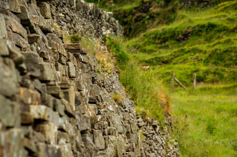
Jenna Trevithick is ankle-deep in a ditch on the edge of a field near Bodmin when she finds what she's been looking for. She crouches, brushes back a mat of dead bracken, and reveals a section of walling that's been hidden for — she estimates, running her hand along the stonework — at least forty years. The technique is unmistakable to her: a particular style of Cornish hedge construction that she associates with this specific part of the moor, a way of interlocking flat-faced stones that she's documented in perhaps thirty other sites within a five-mile radius.
"There," she says, with the quiet satisfaction of someone completing a crossword. "That's what I thought."
Jenna is a landscape historian and a working stonemason, and she has been cataloguing the dry stone walls and Cornish hedges of the far West Country for the better part of a decade. She carries a GPS unit, a camera, a measuring tape, and a battered field notebook that's been through more Cornish weather than she cares to calculate. She is, depending on who you ask, either a dedicated scholar preserving irreplaceable heritage or a slightly obsessive woman who spends a lot of time in fields. She would accept both descriptions cheerfully.
Reading the Land
To most people, a dry stone wall is simply a boundary — a line in the landscape, functional, unremarkable. To Jenna, it's a document. "These structures encode centuries of decision-making," she says, as we pick our way along the field edge. "Every wall tells you something about who owned this land, what they were farming, what materials they had access to, and when the wall was built or rebuilt. It's a kind of writing, just not one most people have been taught to read."
The West Country's walls are not a monolithic tradition. There are distinct regional variations — the characteristic Cornish hedge, which is actually an earth-cored bank faced with stone rather than a true dry stone wall, differs markedly from the slate-pinned walls of west Cornwall, which in turn differ from the moorstone constructions of Dartmoor and the limestone walls of the Mendips. Jenna can identify these variations at a glance, and she's building a database that maps their distribution, their condition, and their likely age.
"The geology drives everything," she explains. "You build with what's under your feet. So the walls are a map of the underlying rock as much as anything else. They're geology made visible."
The Agricultural Palimpsest
Beyond geology, the walls record agricultural history in ways that written records often can't. Field boundaries shifted constantly over centuries — enclosures, divisions between heirs, consolidations during the agricultural improvements of the eighteenth and nineteenth centuries — and the walls show the evidence of these changes in their construction and their alignments.
"You get walls that stop and restart, or change technique halfway along," Jenna says. "That usually means two different builds, two different periods, sometimes two different families. You're looking at the physical record of a dispute, or an inheritance, or a sale."
She shows me a stretch of walling that, to my eye, looks entirely consistent. To hers, it contains at least three distinct phases of construction, identifiable by subtle differences in the stone selection and the coursing. The earliest section, she thinks, dates to the medieval period. The most recent repair was probably made sometime in the mid-twentieth century, using a technique that was already considered old-fashioned by then.
"Somebody came out here — probably an elderly farmer, probably in the 1950s — and fixed this wall the way their grandfather had taught them to," she says. "That's a living tradition, right there in the stonework."
The Mapping Project
Jenna's cataloguing work began as a personal project and has evolved into something considerably more substantial. She now collaborates with the Cornwall and Devon Historic Environment Records, contributes data to the national Historic England database, and runs occasional training days for farmers and landowners who want to understand what they have on their land.
The scale of what remains to be documented is, she admits, slightly daunting. "Cornwall alone has thousands of miles of hedgebank," she says. "I've covered a fraction of it. There's probably a lifetime's work here, and I'm not the only person doing it."
She's not working in isolation — she's connected to a loose network of landscape historians, archaeologists, and enthusiastic amateurs across the region who share data and compare notes. But the work is fragmented, and the funding is precarious. Historic England provides some support; local heritage trusts provide more. It's never quite enough.
Losing Ground
The urgency behind Jenna's work is real. Cornish hedges and dry stone walls are disappearing at a rate that alarms anyone who pays attention. Agricultural consolidation removes field boundaries. Neglect allows walls to collapse and become colonised by vegetation. Development destroys them entirely. The skills required to rebuild them properly are increasingly rare.
"A collapsed wall can be rebuilt if you have the knowledge and the stone," Jenna says. "But once the stone's been carted away and the site's been built on, it's gone. The information is gone. You can't reconstruct what you can't see."
She herself repairs walls when she finds them in danger — she's a competent stonemason, trained through a combination of formal courses and practical experience, and she's rebuilt sections on several farms whose owners were happy to have the help. It's not part of her official remit, but she struggles to leave a wall in distress.
"It feels wrong to document something dying and not try to help," she says simply.
The Bigger Picture
Back at the ditch near Bodmin, Jenna photographs the newly uncovered section from several angles, notes its GPS coordinates, and sketches the construction technique in her notebook. She'll cross-reference this with her existing data when she gets home, and if it confirms what she suspects — a distinct local variant associated with a particular estate's building programme in the early nineteenth century — she'll write it up for the county record.
It's slow work, unglamorous in the way that most genuinely important work tends to be. But Jenna seems constitutionally incapable of finding it anything other than fascinating.
"People talk about the Cornish landscape as though it's natural," she says, pulling her boot free of the ditch with a sucking sound that makes us both laugh. "It's not natural. It's made. Every field, every wall, every lane — somebody decided that. Somebody built that. The landscape is just history that hasn't been demolished yet."
She closes her notebook, tucks it under her arm, and heads for the next field.